At a Glance
- Earl first developed as a tropical storm on Aug. 2, 2016 in the western Caribbean.
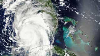
- Earl made landfall as a Category 1 hurricane near Belize City, Belize, on Aug. 4, 2016
- More than three dozen people were killed by Earl in Mexico.
After forming in the western Caribbean on Aug. 2, 2016, Earl made landfall as a Category 1 hurricane near Belize City, Belize, early in the morning on Aug. 4, 2016.
Earl was the first hurricane to landfall in Belize, or anywhere in the western Caribbean Sea west of Jamaica, since Ernesto almost exactly four years ago (Aug. 7, 2012).
A second landfall from Earl occurred southeast of Veracruz, Mexico, late on Aug. 5, 2016.
More than three dozen people lost their lives in Mexico due to landslides caused by Earl's heavy rains.
(MORE: Deadly Impacts in Mexico From Earl)

The system was already impactful prior to being named Earl. Six people were killed in the Dominican Republic as the system passed near the nation July 31-Aug. 1, 2016.
(MORE: 6 Killed in Dominican Republic)
Earl was named late on Aug. 2 after a Hurricane Hunter reconnaissance mission found that an area of low pressure had formed and that it was closed.
Low wind shear, very warm water temperatures, and a lack of dry air allowed Earl to gradually organize and intensify.
Earl became a Category 1 hurricane on Wednesday, Aug. 3, when NOAA Hurricane Hunters found winds of 75 mph. Earl was just off the coast of Honduras at the time.

Earl made landfall on Aug. 4, 2016 near Belize City as a Category 1 hurricane with estimated maximum sustained winds of 80 mph. The main concern across the Yucatan peninsula was for heavy rainfall, but gusty winds did cause problems to.
(MORE: Belize Lashed By Strong Winds, Rain)
Winds gusted to 58 mph for several hours overnight at Phillip Goldston International Airport, west of Belize City, as the eye of Earl passed just to the south of that location around 2 a.m. EDT.
Surge flooding several feet deep was seen in Belize City, as recorded by hurricane storm chaser Josh Morgerman.
Earl entered the Bay of Campeche on Aug. 5 after crossing through Belize, northern Guatemala and southern Mexico.
A vivacious low-level center stayed intact across the Yucatan peninsula, and thunderstorms regrew around the circulation. Earl briefly restrengthened to 60 mph before landfall in eastern Mexico south of Veracruz.
Earl weakened to a tropical depression early on Aug. 6, 2016, after moving back over land and it then dissipated over the mountains later that day.
The remnants of Earl helped play a role in the formation of a tropical system along the Pacific coast of Mexico on Aug. 7.
MORE ON WEATHER.COM: Hurricane Earl (PHOTOS)


